Drone Real Estate Photography: The Complete Guide
Properties listed with drone photography have a 68% better chance of selling faster than listings that rely on ground-level photos alone, according to MLS data compiled by the National Association of Realtors (NAR). Yet despite this advantage, the majority of real estate agents in the US still rely primarily on interior shots and street-level exteriors - a gap that creates real opportunity for photographers and agents willing to differentiate.
Demand for aerial imagery has grown steadily alongside more affordable and capable consumer drones. A DJI Mini 4 Pro weighs just 249 grams (under 0.55 lbs) and retails for around $759 - enough to capture the facade, yard, pool, community amenities, and surrounding neighborhood in a single continuous shot. A 2024 NAR survey found that 85% of buyers expect to see aerial imagery when browsing listings online.
This guide covers how to use drones for real estate photography and videography in the US: which equipment to choose, how to stay compliant with FAA regulations, which techniques produce the most compelling results, and how to structure a professional service.
Why Drone Imagery Sells Properties Faster
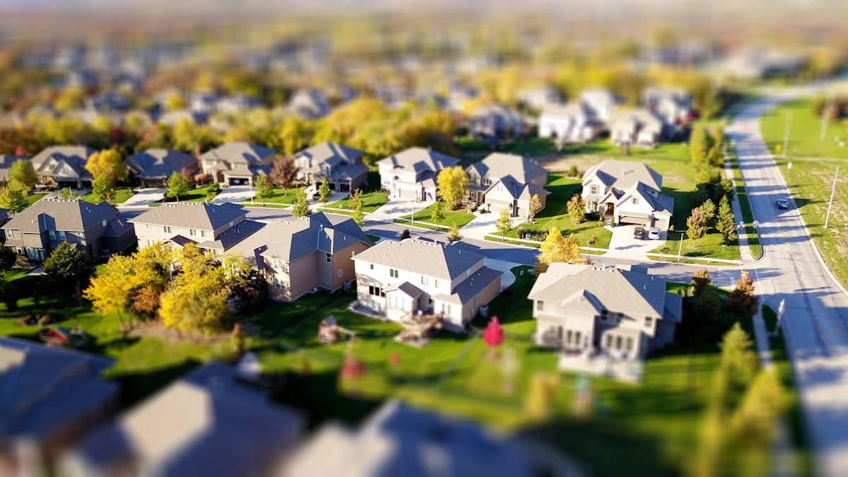
Buyers make visual decisions. A ground-level photo shows the facade; an aerial photo shows the facade plus the yard, the pool, the driveway, the distance to the nearest main road, and the park behind the property. For luxury homes, ranches, commercial developments, and new residential communities, that perspective is decisive.
According to NAR data, listings with aerial video and FPV tours sell up to 70% faster and at prices 5 to 8% higher than comparable properties without that content. Additionally, listings with video receive 403% more inquiries than those without - a figure that applies directly to drone-produced content.
In practical terms, drone footage solves a problem that ground photography simply cannot: properties in new developments, rural areas, or suburban neighborhoods with limited Google Street View coverage get context. A two- to three-minute aerial walk-through positions a property within its real surroundings better than any written description.
Which Drone to Choose for Real Estate Work
Equipment choice depends on the type of property and your budget. For commercial use in real estate, the key criteria are camera quality, image stabilization, and ease of transport.
| Drone | Camera | Weight | Best for |
|---|---|---|---|
| DJI Mini 4 Pro | 4K/60fps, 1/1.3" sensor | 249 g (0.55 lbs) | Residential, beginners |
| DJI Air 3S | 4K/60fps, 1" sensor | 720 g | Luxury, commercial |
| DJI Mavic 3 Pro | 4K/120fps, Hasselblad 4/3" | 958 g | Cinema-quality launches |
The DJI Mini 4 Pro is the most accessible entry point. At 249 grams, it sits just below the FAA's 0.55 lb (250g) registration threshold for recreational flyers - though for commercial use, registration is required regardless of weight. The 1/1.3-inch sensor delivers sharp photos even in low light, ideal for early-morning or late-afternoon sessions.
For luxury properties, the DJI Air 3S is the natural upgrade: a full 1-inch sensor, dual camera (wide + tele), and up to 46 minutes of flight time. The extra latitude in post-production allows more precise color correction and better performance in challenging light conditions.
The DJI Mavic 3 Pro with its Hasselblad camera is reserved for major real estate launches and projects where cinematic quality justifies the investment. It's rarely necessary for day-to-day residential work.
FAA Regulations: What You Need to Know Before Flying
Shooting real estate with a drone in the US is legal - but it requires complying with FAA rules. Ignoring these regulations can result in civil penalties up to $32,666 per violation.
The critical distinction is commercial vs. recreational use. Photographing properties for a real estate agent, broker, or listing platform - even once, even as a favor - constitutes commercial drone operation under FAA rules.
Part 107 Certification
For any commercial drone operation, the FAA requires a Remote Pilot Certificate under 14 CFR Part 107, commonly called a "Part 107 license." To obtain it:
- Pass the FAA Aeronautical Knowledge Test at an FAA-approved testing center (~$175 fee)
- Register on the FAA DroneZone website
- Carry your certificate during all commercial flights
Part 107 rules that apply to real estate work:
- Maximum altitude: 400 feet AGL (above ground level)
- Visual line of sight (VLOS) must be maintained at all times
- Daylight operations (or civil twilight with anti-collision lighting)
- No flight over moving vehicles or people without a waiver
- Controlled airspace: requires LAANC authorization (via Aloft or AirMap apps)
FAA DroneZone Registration
All drones weighing 0.55 lbs (250g) or more must be registered at FAA DroneZone. Registration costs $5 and is valid for 3 years. Your registration number must be displayed on the drone.
For the DJI Mini 4 Pro specifically: at 249 grams it falls under the recreational registration threshold, but commercial operators are still required to register under Part 107 rules regardless of weight.
Flying Near Airports
Properties near airports are common in real estate. For controlled airspace (within airport traffic areas), you must obtain LAANC authorization before flying. Apps like Aloft and AirMap make this straightforward - many authorizations are instant for low altitudes.
Private Property and Privacy
Photographing properties you have permission to shoot is generally fine. However, inadvertently capturing neighbors' yards, windows, or people without consent can create privacy liability. Always stay within the property boundaries when possible, and disclose to the client that the drone will be visible to surrounding residents.
Insurance
While no federal law mandates drone liability insurance for Part 107 operators, it is strongly recommended for commercial real estate work. Property managers and real estate firms increasingly require a Certificate of Insurance before authorizing a shoot. Providers include BWI Aviation Insurance, Global Aerospace, and Skywatch.ai (pay-per-flight).
Regulations Outside the US
Real estate drone photography follows similar rules in most English-speaking markets, though the certification names differ:
- United Kingdom: Commercial drone photography requires a GVC (General VLOS Certificate) from the UK CAA. Third-party liability insurance is legally mandatory for commercial operations. The maximum altitude is also 120 meters (similar to the US 400-foot limit). Real estate agents in London, Manchester, and other major cities routinely commission drone photographers - the market is mature and well-regulated.
- Australia: Paid real estate drone work requires a Remote Pilot Licence (RePL) from CASA, and the operator's company typically needs an RPA Operator's Certificate (ReOC). CASA imposes a 120-meter altitude limit and restricts flight over people without specific authorization. The Australian market is active, particularly in coastal property markets (Sydney, Gold Coast, Perth).
- European Union: Commercial drone photography across EU member states falls under the Specific Category of EASA regulations in most scenarios, requiring an Operational Authorization from the national aviation authority. Some lower-risk operations may qualify for the Open Category A2 subcategory with an A2 CofC (Certificate of Competency). The practical rules - altitude limits, visual line of sight, distance from people - are comparable to Part 107.
Techniques and Angles That Impress
Knowing how to fly isn't enough. The best real estate drone images follow a narrative logic: introduce the property, reveal the context, create desire. These movements are industry standards in the segment:
Orbit (POI - Point of Interest): the drone circles the property with the camera locked on it. Available as an automatic mode on all DJI drones. Result: a complete presentation of the facade and surroundings in a single continuous shot.
Fly-through (Approach): the drone advances in a straight line toward the property entrance while gradually descending. Creates an immersive sense of arrival, widely used in listing videos and luxury portals.
Top-down (Nadir): camera pointed 90° downward, drone moves slowly. Ideal for showcasing pools, landscaped yards, courts, and the footprint of larger lots.
Reveal: the drone rises from behind a natural obstacle - a tree, hill, or wall - progressively unveiling the property. Cinematic and highly effective for homes with panoramic views or wooded settings.
Camera Settings for Real Estate
Always shoot in RAW format (photos) and flat color profile (video) for editing latitude. In-camera settings:
- ISO: as low as possible (100–200) to avoid digital noise
- Shutter speed: 2× the frame rate (60fps → 1/120s) for natural motion blur in video
- ND filter: ND16 or ND32 on sunny days to control exposure
- Color profile: D-Log M on DJI drones preserves detail in both shadows and highlights
The best time to shoot is golden hour - the 30 minutes after sunrise or before sunset. Raking light enhances facade texture, creates long shadows that give the yard depth, and eliminates the blown-out sky that ruins midday shots.
Pricing Your Real Estate Drone Services
The US market for real estate drone photography has more established pricing than many markets, driven by high demand in coastal metros and luxury segments:
| Package | Deliverables | Average Rate (US market) |
|---|---|---|
| Basic | 10–15 edited photos | $150–$300 |
| Standard | 20–30 photos + 2-min video | $300–$600 |
| Premium | Photos + video + 360° virtual tour | $600–$1,200 |
| Luxury Launch | Photos + cinematic video | $1,200–$3,500+ |
Mid-sized real estate agencies often establish monthly retainer agreements with drone photographers, covering 8 to 15 properties per month. This recurring model is financially more predictable than negotiating per session.
For context, comparable rates in other English-speaking markets:
| Market | Standard package | Premium package |
|---|---|---|
| United Kingdom | £200–£450 | £450–£1,000 |
| Australia | AUD 350–700 | AUD 700–1,800 |
| Canada | CAD 350–650 | CAD 650–1,500 |
For those starting out, the most direct path is to contact independent agents in your area and offer the first two shoots at a discount in exchange for portfolio content and a testimonial. A curated gallery of 20 properties on Instagram generates organic referrals quickly - especially when posts are tagged with neighborhood hashtags and location data.
Post-Production: Editing Real Estate Photos and Video
The final delivery determines whether a client books again. Underexposed photos, a crooked horizon, or cool color casts drive buyers away even when the property itself is excellent.
For photos, the standard workflow is to import RAW files into Lightroom or Capture One, adjust white balance to warm tones, correct lens distortion, and export as JPEG at 4,000 pixels on the long edge, quality 90%.
For video, DaVinci Resolve - free in its base version - has all the tools needed to process D-Log M footage. The typical structure of a two-minute property video:
- Aerial overview of the surroundings (15 seconds)
- Approach to the entrance (10 seconds)
- Facade and exterior (20 seconds)
- Amenities - pool, outdoor kitchen, garden (15 seconds)
- Panoramic view at sunset (15 seconds)
- End card with address and contact info (10 seconds)
The soundtrack must be licensed for commercial use. Epidemic Sound and Artlist are the go-to options for photographers delivering to real estate clients. Using unlicensed YouTube audio creates copyright restrictions on the client's listings - a problem that can cost you future contracts.
FAQ
Sources: National Association of Realtors - Drones | MLS Real Estate Photography Stats - RubyHome | FAA - Part 107 Commercial Operators | FAA DroneZone
More like this
Related Articles
Best Drones for Remote Workers & Office Creators (2026)
Best drones for remote workers in 2026: compact, sub-249g picks for content creators and digital nomads who film from home, the of…
UK CAA Drone Rules 2026: IDs, Fees, and Fines Explained
UK drone rules changed on January 1, 2026: registration now kicks in at 100g, not 250g. Full Flyer ID, Operator ID, A2 CofC, and f…
EASA Drone Categories: Open, Specific, Certified (2026)
EASA splits every EU drone flight into Open, Specific, or Certified. Here's which category you're in, which C-class you need, and…