Aerial Mapping with Drones: A Photogrammetry Guide
A traditional survey team might spend two weeks mapping 500 acres using conventional leveling equipment and total stations. With a drone and photogrammetry software, the same work is completed in four hours - with centimeter-level accuracy and a complete 3D model of the terrain as the deliverable.
Drone aerial mapping has moved well beyond the niche of specialized firms. It's now part of the daily workflow for civil engineers, agronomists, geologists, mining operators, and construction project managers worldwide. Equipment costs have dropped, hardware has become more capable, and software has simplified a process that once required geodetic training to execute.
This guide explains the full process from start to finish: from mission planning to generating the final map, covering the right equipment choices and the most-used software tools across the industry.
What Is Photogrammetry and How Drones Transformed Surveying
Photogrammetry is the technique of extracting measurements and geometric information from photographs. The concept dates back to the 19th century - early photogrammetrists used cameras mounted on balloons to produce military maps. What changed with drones was scale, cost, and speed.
Before drones, collecting photogrammetric data over large areas required manned aircraft - with costs that made smaller projects impractical. Results took days or weeks. With professional-grade drones starting around $2,000 to $5,000 and cloud-based processing software, the same output is accessible to any engineering firm, agricultural operation, or construction company.
A drone photogrammetric survey generates four primary types of deliverable:
- Orthophoto (orthomosaic): a geometrically corrected aerial image equivalent to a high-resolution satellite photo, used for accurate planar measurements
- Digital Surface Model (DSM): 3D representation including vegetation and structures
- Digital Terrain Model (DTM): bare-earth terrain without objects above it, used for grading and hydrology projects
- Point cloud: millions of 3D coordinates forming a detailed geometric model of the area
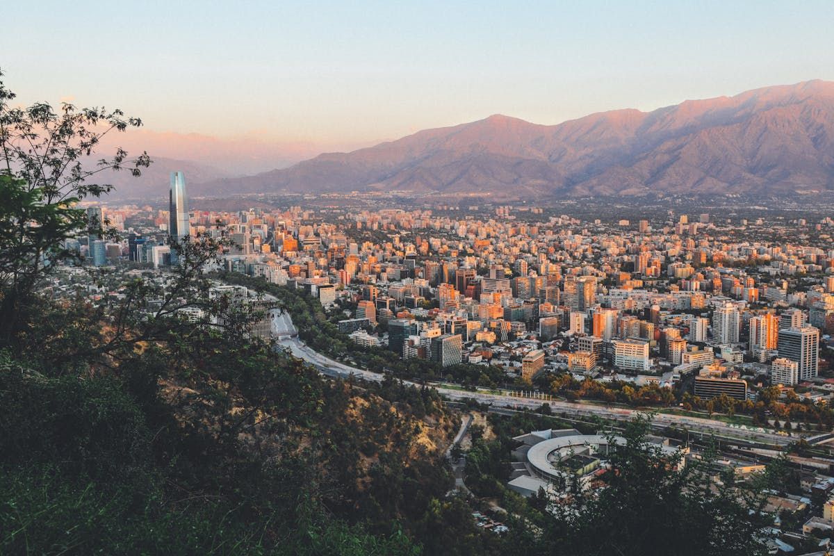
Resolution depends on flight altitude: at 100 meters (330 feet), a drone with a 20MP camera produces orthophotos with 2.5 cm/pixel resolution - enough detail to identify soil erosion channels, pavement cracks, and individual utility poles.
How the Process Works: From Flight to Map
Drone aerial mapping follows four sequential steps. Each one directly influences the quality of the final product.
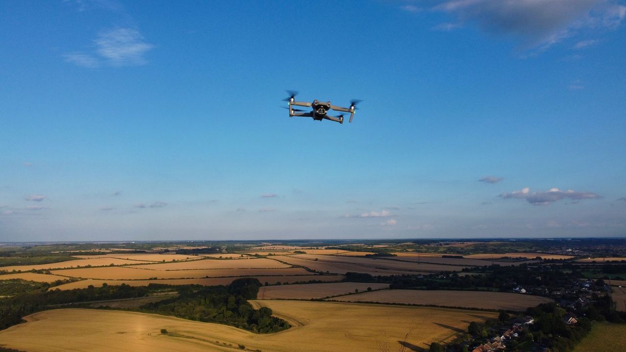
1. Mission Planning
Everything begins before the flight, in mission planning software. Tools like DJI Pilot 2, Litchi, or DroneDeploy allow you to define the area to be mapped, and the software automatically calculates the flight lines in a grid pattern (lawnmower), along with altitude, speed, and camera trigger interval.
The most critical parameters are front overlap (between consecutive photos on the same flight line) and side overlap (between adjacent flight lines). The standard for quality mapping is 80% front overlap and 70% side overlap. More overlap means more photos, more processing time, and longer flight time - but more accurate results.
2. Ground Control Points (GCPs)
GCPs (Ground Control Points) are physical markers placed on the ground with known geographic coordinates, measured using a precision GPS receiver or total station. The software uses these points as geographic anchors to eliminate accumulated positioning errors from the drone.
For projects requiring centimeter accuracy - topographic surveying, civil engineering, mining - GCPs are essential. Drones with integrated RTK (Real-Time Kinematic) receivers, like the DJI Phantom 4 RTK and DJI Mavic 3 Enterprise, receive real-time corrections and can eliminate the need for physical GCPs, dramatically reducing fieldwork time.
3. Image Processing
After the flight, the hundreds or thousands of photos collected are imported into photogrammetry software. The process uses an algorithm called Structure from Motion (SfM) that identifies common points across overlapping photos, reconstructs the 3D geometry of the space, and generates the point cloud.
Processing is CPU and GPU intensive. A 125-acre area with 400 photos can take 1 to 6 hours depending on the hardware and quality settings. Cloud platforms like DroneDeploy and Pix4Dcloud offload this processing to remote servers, delivering results without depending on local computing power.
4. Data Export
The final product is exported in the formats required by the client's workflow: GeoTIFF for orthophotos (compatible with QGIS, AutoCAD, ArcGIS), LAS/LAZ for point clouds, DXF for contour lines in CAD software, and 3D formats like OBJ or PLY for visualization and modeling.
Which Drone to Use for Aerial Mapping
Equipment choice depends on project scale, accuracy requirements, and available budget. There is no single ideal drone for all contexts.
Beginners and Small Areas (up to 125 acres / 50 ha)
The DJI Mini 4 Pro (48MP camera, 34-minute battery life) is an accessible entry point for those wanting to explore mapping without heavy investment. It has reliable GPS and produces orthophotos of sufficient quality for less demanding projects. The limitation is the absence of RTK - planimetric accuracy without GCPs is approximately 3 to 10 feet (1 to 3 meters).
Professional Use and Medium Projects (125–1,250 acres / 50–500 ha)
The DJI Mavic 3 Enterprise with the RTK module is the balance point between portability and professional-grade accuracy. 20MP camera, 45-minute battery life, integrated RTK, and compatibility with DJI Terra software. Vertical accuracy of 1.5 cm and horizontal accuracy of 1 cm with RTK active - sufficient for most topographic surveying and civil engineering projects.
Large-Scale and High-Precision Projects
The DJI Phantom 4 RTK remains the benchmark in many surveying and mining firms for its robustness and mature software ecosystem. For areas above 1,250 acres (500 ha) or projects requiring multiple daily flights, fixed-wing platforms like the senseFly eBee X or WingtraOne GEN II offer superior endurance (60 to 90 minutes) and greater coverage per flight.
Best Photogrammetry Processing Software
The drone collects the raw data. The software transforms those photos into usable maps. The choice of processing tool is as important as the choice of drone.
Pix4Dmapper
The industry standard for professional projects. Local processing with full parameter control, compatible with all camera types and mission types. Offers specific modules for agriculture (Pix4Dfields), inspection, and point clouds. Subscription pricing from $350/month - the cost reflects the precision and advanced feature set.
DroneDeploy
A cloud-based platform with an intuitive interface focused on ease of use. Popular in construction and agriculture for its automatic reporting and integrations with project management platforms. Processing happens on the company's servers - no need for powerful local hardware. Plans starting from $329/month.
Agisoft Metashape
A desktop solution with a perpetual license ($3,499 for the professional version), no monthly fee. Widely used in academic research and projects requiring full control of the processing workflow. Supports multispectral and thermal cameras beyond RGB. Steeper learning curve, but maximum flexibility.
OpenDroneMap (ODM)
The only complete open-source alternative for photogrammetry. Free, with an active community, producing results that rival paid solutions in many scenarios. Can be installed locally or used via WebODM, a web interface accessible even to those unfamiliar with command-line tools. Ideal for budget-constrained projects or for those learning the process at no cost.
DJI Terra
DJI's native software, included free with Enterprise-line drones. Limited to DJI equipment but offers seamless integration with compatible models. Suitable for basic mapping projects without the need for advanced processing.
Industry Applications
Drone aerial mapping has applications across virtually every sector that works with physical space. These are the industries where demand is strongest and ROI is most clearly demonstrated.
Agriculture and Precision Farming
In large-scale agriculture, photogrammetric mapping enables generation of vegetation index maps (NDVI and NDRE) with multispectral cameras, calculation of grain volumes in storage silos, and optimization of application routes for pesticides and fertilizers. A 2,500-acre farm mapped weekly through a crop cycle accumulates data that allows correlation between productivity, soil management, and water distribution - precision impossible with any other technology at comparable cost.
Topographic Surveying
The original application and still among the most intensive. Volume calculations for cut and fill, contour line generation, slope conformity verification, and erosion monitoring. Projects that previously required weeks of fieldwork by multi-person crews are completed in hours by a single qualified operator with a laptop and processing software.
Construction and Infrastructure
Construction sites are mapped weekly to track progress, verify conformance against design drawings, and communicate visually with remote clients and managers. Comparing the current 3D model to the original engineering design identifies deviations in real time - before they become expensive rework. Major infrastructure projects (highway construction, dam monitoring, bridge inspection) are among the most active commercial mapping sectors.
Mining
One of the applications with the highest financial return. Calculating volumes of ore stockpiles and waste dumps with 1 to 3% accuracy replaces manual estimates that could be off by 15 to 20%. Mining companies report annual savings in the millions simply from improved inventory management and haul truck optimization based on accurate mapped volumes.
Environmental Monitoring
Drone mapping adds a quantitative layer to environmental monitoring: beyond detecting deforestation or wildfire damage, it allows calculation of exact affected areas, monitoring of vegetation regeneration, and production of georeferenced technical reports for regulatory compliance. Conservation organizations and environmental agencies use photogrammetric data to document land change over time at scales and costs previously unavailable.
FAA Regulations for Commercial Aerial Mapping
Commercial drone mapping in the US follows FAA Part 107 rules, with some specific considerations for professional use.
Any mapping operation where you receive compensation - from a client, an employer, or indirectly - constitutes commercial drone operation and requires a Remote Pilot Certificate under 14 CFR Part 107. This means passing the FAA Aeronautical Knowledge Test (~$175) at an approved testing center and registering at FAA DroneZone.
Key Part 107 rules for mapping operations:
- Maximum altitude: 400 feet AGL (above ground level) without a waiver
- Visual line of sight (VLOS) required at all times - for large mapping areas, this may require multiple launch points or a visual observer
- Controlled airspace: requires LAANC authorization via Aloft or AirMap before flying near airports or other controlled areas
- Waiver for operations beyond VLOS (BVLOS): large-scale mapping over extended areas may require a Part 107 waiver for BVLOS operations, which must be applied for through the FAA
Professional liability considerations: unlike in some countries, there is no federal regulation in the US requiring aerial survey data to be certified by a licensed surveyor or engineer simply because it was collected by drone. However, state licensing laws vary - in some states, producing deliverables labeled as "surveys" requires a licensed Professional Land Surveyor (PLS) to review or certify the output. If your clients are submitting mapping data for permitting, legal boundary work, or government contracts, confirm local licensure requirements.
Insurance: liability insurance is strongly recommended for commercial mapping operations. Most enterprise clients require proof of coverage before work begins.
Regulations for Commercial Mapping Outside the US
Aerial mapping is a global profession, and the regulatory framework in other major markets is broadly comparable to Part 107:
- United Kingdom: Commercial mapping requires a GVC (General VLOS Certificate) from the UK CAA for standard VLOS operations. For large-area mapping that requires BVLOS, an Operational Authorization from the CAA is needed. The CAA's guidance recognizes aerial survey and photogrammetry as a common commercial use case. Altitude limit: 120 meters (similar to the US 400-foot limit). Regarding surveyor licensing: producing topographic data for legal or planning submissions may require review by a Chartered Surveyor (RICS) depending on the application.
- European Union: Commercial mapping across EU member states typically falls under the Specific Category of EASA regulations. Most operations at standard altitudes qualify for the STS-01 or STS-02 Standard Scenarios, which require an A2 CofC and some additional procedural documentation. The EU has also developed specific guidance on drone data in cadastral and infrastructure contexts - requirements for certified surveyor oversight vary by member state.
- Australia: Commercial mapping requires a Remote Pilot Licence (RePL) and the operating company must hold an RPA Operator's Certificate (ReOC). BVLOS mapping - increasingly common for large agricultural or infrastructure projects - requires specific CASA approval. Australia has a strong commercial mapping market, particularly in mining (Queensland, Western Australia) and agriculture.
- Canada: Transport Canada requires a RPAS Pilot Certificate - Advanced for complex operations including beyond visual line of sight. The Canadian market for professional photogrammetry is growing, particularly in forestry (British Columbia) and resource extraction.
FAQ
Sources: Pix4D - What is Photogrammetry? | FAA - Part 107 Commercial Operators | DJI - Phantom 4 RTK | DroneDeploy - Construction Mapping | Agisoft Metashape
More like this
Related Articles
Best Drones for Remote Workers & Office Creators (2026)
Best drones for remote workers in 2026: compact, sub-249g picks for content creators and digital nomads who film from home, the of…
UK CAA Drone Rules 2026: IDs, Fees, and Fines Explained
UK drone rules changed on January 1, 2026: registration now kicks in at 100g, not 250g. Full Flyer ID, Operator ID, A2 CofC, and f…
EASA Drone Categories: Open, Specific, Certified (2026)
EASA splits every EU drone flight into Open, Specific, or Certified. Here's which category you're in, which C-class you need, and…